- عربي
- Ukraine
- Economy
-
Investment
- Current Investment Trends
- Legal Conditions of Doing Business
- Investment Policy
- Competition
- Setting a Business in Ukraine
- Mergers and Acquisitions
- Taxation
- Import and Export
- Banks and Bank Regulation
- Convertibility and Profits Repatriation
- Currency Regulation
- Protection of Intellectual Property Rights
- Companies
- Travel to Ukraine
- About us
- Useful Sites
- Gallery
- News
Currency rates in UAH
| AED | ||
| BHD | ||
| EGP | ||
| KWD | ||
| LBP | ||
| OMR | ||
| QAR | ||
| SAR | ||
| SYP |
2015-07-06
| Kiev |  |
+32 |
| Donetsk |  |
+28 |
| Dnipropetrovsk |  |
+31 |
| Lviv |  |
+31 |
| Odessa |  |
+27 |
Geographic Location
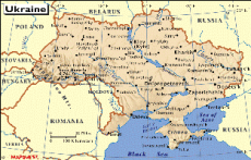
According the maps Ukraine has a strategic position in East Central Europe as it is located on the crossway of European and Asian countries, according to the political map of Ukraine. It is the second largest country by area on the European continent, consolidating 24 administrative regions – “oblasts” and Autonomous Republic of Crimea. Detailed map of Ukraine depicts 459 cities, 885 towns and 28 450 villages.Reviewing closely Ukraine’s physical map, one may observe the differences in the landscape. Namely, grassy fertile plains with average height 175 meters above the sea level prevailing on the east and center of the country and constituting 95% of the total area. Moderate elevation exists only on 5% of the area, these are the Crimean and Carpathian mountains on the south and west of the country. The highest pick on Ukraine’s map is located in the west. Mount Hoverla in the Carpathians reaches 2, 061 m above the sea level.
In the aspect of nature country enjoys a range of natural resources, arable and farming areas cover 42 million sq km (71% of the general country area) as the country has plenty of black-colored soil, known as chernozem, which contains a high percentage of humus. Seas, rivers and lakes can be explored on the detailed map of Ukraine. The country is washed on the south by the Black Sea and the Sea of Azov, big rivers’ net is composed by Dnieper, Danube, Dniester, Seversky Donets, Southern Bug, Pripyat and Desna. There are over 3000 lakes on the territory of Ukraine; mostly they are either middle or small sized. The biggest natural lake is Yalpug (Odesa oblast), the deepest – Svityaz (Volyn oblast).
Climate map of Ukraine displays temperate continental climate covering most of country’s area with only slight line of Mediterranean climate wrapping Crimean Peninsula.
Location:
Eastern Europe, bordering the Black Sea (Bulgaria, Turkey), between Poland, Hungary, Romania, and Moldova in the west and Russia in the east
Geographic coordinates:
49 00N, 32 00 E
Map references:
Asia, Europe
Area:
Total: 603, 700 sq km
Land boundaries:
Total: 4,664 km
Border countries: Belarus 891 km, Hungary 103 km, Moldova 939 km, Poland 526 km, Romania (south) 169 km, Romania (west) 362 km, Russia 1, 576 km, Slovakia 97 km
Coastline:
2,782 km
Climate:
Temperate continental; Mediterranean only on the southern Crimean coast; precipitation disproportionately distributed highest in west and north, lesser in east and southeast; winters vary from cool along the Black Sea to cold farther inland; summers are warm across the greater part of the country, hot in the south
Terrain:
Most of Ukraine consists of fertile plains (steppes) and plateaus, mountains being found only in the west (the Carpathians), and in the Crimean Peninsula in the extreme south
Elevation extremes:
Lowest point: Black Sea 0 m
Highest point: Hora Hoveral 2,061 m
Natural resources:
Iron ore, coal, manganese, natural gas, oil, salt, sulfur, graphite, titanium, magnesium, kaolin, nickel, mercury, timber, arable land
Land use:
Arable land: 71%
Permanent crops: 1.5%
Other: 44.7% (2005 est.)
Irrigates land:
22,080 sq km (2003 est.)
Environment – international agreements:
Party to: Air Pollution, Air Pollution-Nitrogen Oxides, Air Pollution-Sulfur 85, Antarctic-Environmental Protocol, Antarctic-Marine Living Resources, Antarctic Treaty, Biodiversity, Climate Change, Climate Change-Kyoto Protocol, Endangered Species, Environmental Modification, Hazardous Wastes, Law of the Sea, Marine Dumping, Ozone Layer Protections, Ship Pollution, Wetlands
Signed but not ratified: Air Pollution-Persistent Organic Pollutants, Air Pollution-Sulfur 94, Air Pollution-Volatile Organic Compounds
Geography – note:
Strategic position as the crossroads between Europe and Asia; second-largest country in Europe


